This road trip is one of two which took us across Morocco, documented in 4 parts. See more in Part 2, Part 3 and Part 4 of the series.
We arranged a driver to take us, 6 people, from Fes south to Merzouga, the gateway to the Sahara Desert. The journey in a Mercedes minivan started at 7:30 am and covered almost 500 km in one day. While Google Maps estimated 7.5 hours, the journey stretched to more than 10 hours with rest stops—a full day of crossing Morocco’s shifting landscapes.
And yes, Ethiopian jazz from the 1960s, it kinda set the mood for the ride.
Leaving the urban outskirts of Fes, we drove across a broad plain before the road began climbing into the Middle Atlas Mountains, the northernmost and second-highest range of Morocco’s Atlas chains.
From the car window, the mountain shadows stretched dramatically across the plains, though many photos blurred as they were taken from a moving vehicle.

Our first stop was at Ifrane at 1,665 m (5,463 ft). It seemed that this is a popular tourist rest-stop; several vans (like ours) and tour buses were already parked in front of a cafe. We got out to stretch our legs and it was surprisingly chilly. We all ordered a hot chocolate in the cafe and stood around a gas fireplace.
Ifrane, Morocco’s “Little Switzerland”
Ifrane has a prestigious university – Al Akhawayn University (saw the signs) – that teaches in English. I found out later that my employer’s local affiliate recruited many of its graduates from this establishment.

This area enjoys sufficient snowfall during the winter months that it becomes a ski resort – often compared to Switzerland by the locals due to the architecture – chalets with steep roof. It is also popular in the summer for its more temperate climate when compared to that of Fes.

The Middle Atlas, stretching 350 km northeast across Morocco, is renowned for its biodiversity, contrasting sharply with the desert beyond. The region shelters endangered Barbary macaque monkeys and ancient cedar forests.

Our driver paused so we could watch a small troop of macaques before continuing through snow-dusted passes.

A satalite view shows how the biome changes from mountains with evergreen forests to rocky mountains with snow and then to desert.
Descending the Middle Atlas via Route Nationale N13, we entered a desert plain facing the imposing High Atlas Mountains. This range runs from the Atlantic coast to the Algerian border, forming a weather system barrier between the Mediterranean north and the Sahara to the south.

We believe snowmelt from the High Atlas mountains sustains agriculture in the plains despite the rain-shadow effect.

We took a short break at the small town of Zaida to buy some fruits and masks (DL was rightly worried about the shortage) from the local pharmacy that also sold veterinary drugs (the only time I have entered a drugstore that supplies humans and their animals).

Lunch was at Hotel Taddart, just outside Midelt—a large stopover popular with bus tours. The restaurant resembled a campus canteen, with standard tourist fare at higher prices. Still, the break offered a chance to stretch and observe fellow travelers, including the largest group of Asian tourists we encountered in Morocco (there were at least 3 full tour bus worth of tourists).

Midelt
Midelt is the provincial capital situated at 1,500 metres (5,000 ft) in the high plains between the Middle Atlas and High Atlas mountain ranges. It is at about the same elevation as Denver, Colorado, United States – the mile-high city.

Continuing on the highway N13, we crossed the central Moroccan plain and negotiated our passage across the High Atlas at the dramatic Gorge du Ziz.

The River Ziz (Oued Ziz), which flows out of the High Atlas and into Algeria (over 200 km), is important as it irrigates all the agricultural lands south of the High Atlas.

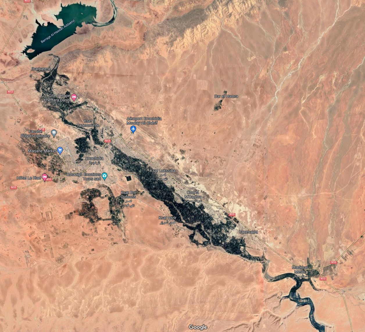
The River Ziz widens at one point to form the Barrage Al-Hassan Addakhil, just outside the town of Errachidia.

Around the junction of N10 and N13, near Ibarbatene, we stopped for snacks and bathroom, and admired the view of the Ziz valley.
Where there is water, there are palm trees. The Ziz river around Errachidia flows like a green ribbon snaking across a vast expanse of featureless yellow background. It is essentially a very long and narrow oasis. Click on the image to get a bigger version of it.

Erfoud and the Desert Gateway
As we approached the oasis town of Erfoud, the terrain became flat and the surroundings started to look like a semi-arid desert. Since leaving Fes, we had passed through at least three biomes.

Erfoud was the filming location of The Mummy, Prince of Persia and Spectre (James Bond), and is best known for fossils. Erfoud is the last major town before the Sahara dunes. Beyond Erfoud lies Rissani, a traditional market town and the closest hub to Erg Chebbi sand dunes—our final destination.

This route is apparently a well-trodden path for those who wants to see the Sahara coming from Fes. N13 is a single lane highway which ends at Taouz not far further south. Imagining traffic jam, we were glad that this trip was not made during the peak European holiday season.

Arrival at Merzouga
By early evening, we reached Merzouga, a desert village just 35 km (22 miles) southeast of Rissani and only 50 km (31 miles) from Algeria. Merzouga serves as the base for Sahara tours, where nearly every business caters to visitors—hotels, quad rentals, camel treks, and tour operators.

We reached the end of our day-long ride in the minivan, and were transferred to a 4×4 SUV somewhere on N13, past Merzouga but before Khemliya. As far as we could observe, all the activities in Merzouga and Hassilabied (a village nearby) are associated with tourism, hotels, quad rentals, restaurants, tour operators, etc. I read somewhere, that people call this area a desert theme park.

We transferred into two 4×4 SUVs (no single vehicle could seat all six of us) and drove off-road for 15 minutes past Merzouga toward our desert camp. Arriving just after 6 pm, we were greeted warmly by camp staff as the sun set over the Erg Chebbi dunes, our SUV casting long shadows on the sand.

After nearly 11 hours of travel, we were exhausted yet exhilarated—the landscapes of Morocco had shifted from urban plains to alpine forests, rugged gorges, palm oases, and desert dunes in one unforgettable day.
To read more, click these links to see Part 2, Part 3 and Part 4 of the series.
One response to “Road trip in Morocco #1 – from Fes to Merzouga”
Amazing Morroco!